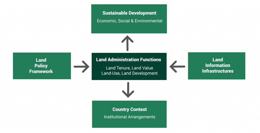
Geo-LandMARC is dedicated to advancing research within an extended form of the components that comprise the Land Management Paradigm framework defined by Stig. Enemark (2005)*.
Land management refers to activities undertaken to manage land as a resource for sustainable social, environmental, and economic development. It comprises four components, with the central operational component being Land Administration, which is further divided into four functions: land tenure, land value, land use, and land development. The other three components that are interconnected with the Land Administration are (i) Land Policies for various sectors; (ii) Land Information Infrastructures such as Geographical Information Systems (GIS), Spatial Data Infrastructures (SDIs), and Planning and Decision Support Systems; and (iii) the country context in terms of the relevant legal frameworks, institutional bodies and their relevant jurisdictions, stakeholders involved, and citizens. All four interconnected components of land management aim to achieve sustainable development, as defined by the UN Agenda 2030.

* Enemark, S. (2005). The Emerging Land Management Paradigm. A Major Challenge for the Global Surveying Community, RICS Evening Lecture Series, RICS, London.
Geo-LandMARC Lab focuses on advancing research and innovation within the Land Management paradigm to support sustainable development.
Our key areas of expertise include the following:
– Land administration, that refers to the study of cadastral systems, including land tenure, land valuation and land markets as well as spatial planning related to land use planning and land development.
– Land policies focus on primary land management planning approaches such as land consolidation, land readjustment, and support through geospatial technologies of sectoral land management policies related to the environment, natural resources, forestry, and so on.
– Land information infrastructures, that include the utilisation and the development of Geographical Information Systems/Science (GIS/GISc), Land Information Systems (LIS), Planning and Decision Support Systems (PDSS), and their integration with artificial intelligence (the emerging field of GEO-AI) and other advanced geocomputational methods.
– Land legislation and institutional frameworks in terms of their formulation and development for effective land management related to land administration, land policies, and land information infrastructure.
Our mission is to advance sustainable development by conducting high-calibre research and implementing innovative practices in geospatial information systems and technologies to support the components and functions of land management. Our vision is to become a leading regional research hub that contributes to the future of land management for the sustainability of our planet by leveraging excellence in research and technology.
Dr. Demetris Demetriou
Coordinator of Geo-LandMARC Lab
Department of Civil Engineering and Geomatics
Cyprus University of Technology
Design and Developed by antigonikastudio